Wade Building
MIXED-USE
12 story, (3) commercial-height floors, (9) residential-height floors
Library Square, Central City Neighborhood, Downtown Salt Lake City
USE SUMMARY:
56% Hotel, 274 guestrooms, 36 suites
25% Parking 300 ADA accessible stalls, automated storage below grade
13% Neighborhood services
- conference center
- grocery
- restaurant
- spa and fitness
- (2) bars, one rooftop, one at lobby
- rooftop pool
- theater
- art gallery
- cafe
- co-working
6% Support and circulation spaces
Project narrative
Location
The site is accessible to the Library TRAX station via Moffat Ct. It is near many excellent restaurants in the iconic and historic east downtown neighborhood. A pedestrian through-block access to connect to Moffat Ct. is proposed, to be secured at night and open during business hours.
Architectural design
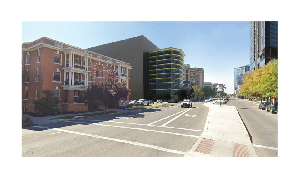
The architectural design in based on our urban history, combined with our high mountain setting. The front wing is 10 stories and highly transparent, as shown above. It makes reference to the cornices of downtown’s historic tall buildings, the Boston Building and similar early Salt Lake City buildings.
Away from the street, the building is 2 stories higher at 12 stories, and emphasizes privacy with a glass façade which allows views out but not in. The material is a smoke matte-patterned obscure glass, mirrored on one side and installed in a geometric pattern like fractured stone. While light is brighter outside than in, the glass will appear opaque like stone from the exterior. This is to refer to the monolithic West Slabs of Mt Olympus. The structure of that mountain, made up of a series of slabs turned on end is used in the design of the south face of the building as well, where individual slab-ends are exposed to give privacy to patio spaces.
The south façade is designed to be planted with native plants of our local mountains. The planting of the southern face continues on the south end of the roof which is reserved for a rooftop bar, pool, hot tub and terrace. This area is called the Saddle, after the park-like area between the twin peaks of Mt. Olympus. The remainder of the roof that is not needed for mechanical equipment is reserved for the kitchen garden of the on site restaurant.
A double-skin façade is used at most of the residential spaces to provide passive heating and cooling, better insulation from noise, a garden-like view from the interiors, and more space for maintaining plants year-round.
Primary use – boutique hotel
The primary proposed use is R-1, hotel, to house a neighborhood inspired non-prototype hotel that caters to guests who want to stay in a neighborhood setting, interacting with locals in a place that is designed to reflect the area. This site location is an ideal neighborhood setting for the intent of the hotel brand. It is at the meeting place of several downtown zones – central business district, transit oriented, and public lands – and sits in the residential district. The hotel brand focuses on providing services and places of gathering for locals and hotel guests to interact.
Skywalk Planned Community
RURAL TOWN CENTER COMMUNITY DESIGN
250 acres, Tooele County, east of Grantsville

Project Narrative
Summary
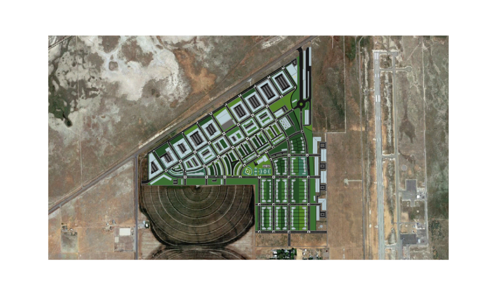
Skywalk bridges Tooele Airport and the recent Midvalley Highway. It is a walkable and bikeable node community embracing Tooele County’s General Plan. It is geared to land conservation and increasing area independence.
Skywalk has been approved by the Tooele County Planning Commission. Skywalk:
- is a walkable and bikeable town center plan,
- has a variety of residence types,
- hospitality,
- education,
- medical center,
- entertainment,
- dining,
- a system of parks connected by trails and
- a full range of community services for the township of Erda, Grantsville and surrounding rural areas.
Skywalk is highly accessible. It has a central location with respect to the existing centers of population, it acts as a node of services between 2 interchanges of the Midvalley Highway. It is a neighbor to the Tooele Valley Airport and an existing single-family area.
Skywalk Planned Community is not on prime farmland. The site is extremely alkaline, a shadescale-dominated ecoregion, with limited use for grazing. The majority of the site has not been farmed productively for several years.
Community Integration
Skywalk is a highly site-specific traditional mixed-use town center that strives to look like it belongs in Tooele County. Skywalk achieves a quiet blend with the surrounding landscape in soft edges of open space and trails; with the airport by supporting business park; and with the existing large-lot rural housing community by its own area of higher density detached multi-generational homes.
Skywalk engages new freeway frontage as a compact node. The built area narrows and thins down in density of use toward the south. It meets the existing residential neighborhood with an 11-acre natural conservation space.
Architectural unity to encourage walkability is based on a style made to fit Tooele:
- building that appears new,
- using domestic and humble classical themes of European settlers simplified and made contemporary, and
- built in locally available materials such as the native stones.
- Classical modules or proportions are maintained for consistency in variety.
Only desirable landmarks are allowed to be higher than a general 4-story restriction. High density is achieved by this low but consistent height. Storefront engagement exists throughout a grid of small mixed-use blocks. On-street parking is throughout to provide protection for pedestrians and support commercial vitality, while parking lots are always hidden.
Purposes and Needs
Purposes and needs this area were defined by the County with public input in the Tooele County General Plan Update 2016. Primary purposes and needs of development included:
1) Increased area independence,
2) Walkable / bikeable clustered development,
3) Preserving small town feeling,
4) Providing for public transit and employment with a balance between open space, agriculture and new economic development.
Skywalk is located in the west end of the Erda Township area, or the east end of Grantsville. Erda is defined in the County Plan as having a dependence on septic systems that promoted sprawl. Average lots are 2 acres. Housing variety is limited. Home costs are uniformly high. Public transit and infrastructure are currently unsupportable due to the low density. Grantsville had the longest average commute in the state according to the census most recent during the design. Employment in the area is dependent is on outside communities.
The design is meant to conserve area agricultural land from sprawl while providing for growth. It will reduce driving, increase physical activity and the feeling and operation of a local community. Skywalk is designed as a small walkable town center having:
- more full-time equivalent jobs than housing units proposed
- a wide variety of office and light industrial space,
- a perimeter of parks and open space,
- a variety housing types at higher density.
Transferability
The most walkable places are the cores of large cities. The Skywalk site is small for a town center at about 250 acres. Research for Skywalk frequently came up against the critical elements of establishing walkability at their threshold of functioning.
Programming research was often focused on finding workable minimums when surrounded by a vacuum. The basic search was for a critical threshold of variety of services where successful walkability begins. This community is supported by a 10-hour employed community on-site, a smaller 18-hour residential community on-site, and an off-site residential community that would arrive primarily by car from the surrounding rural areas.
Minimum levels of residential density for supporting the large variety of commercial and community services needed to reach walkability were achieved by pulling building toward a dense center and working toward a complex community of about ½ mile radius. Overall, the density is only 4 units per acre.
There is widespread potential for stand-alone walkable nodes to change the face of rural life. Miles driven for commuting could be significantly decreased with an increased independence of rural areas.

